
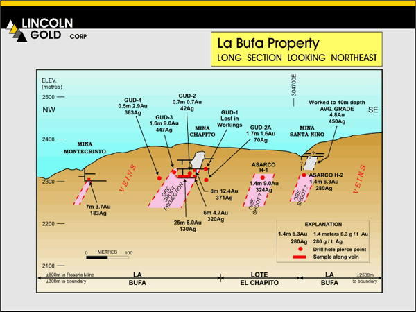
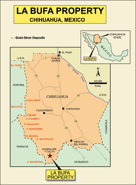
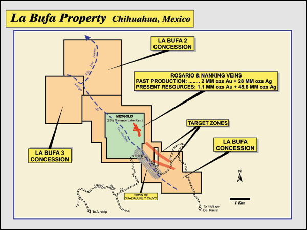
In the summer of 2005, Lincoln entered into a joint venture with Almaden Minerals Ltd. (TSE-listed) to explore and develop the La Bufa gold-silver property located in the Guadalupe y Calvo district, Chihuahua, Mexico. The district lies within the Sierra Madre Occidental along a north-south trend that encompasses numerous gold-silver mines and deposits to include Mulatos, Dolores, Ocampo, and El Sauzal. Lincoln can earn up to a 60% interest in the property over a 4 year period by spending US$3.0 million in work expenditures and by giving Almaden 450,000 Lincoln shares. Access to the property is excellent via a new paved highway and power, water, and labor are available at the adjacent town of Guadalupe y Calvo. Historical production (1834-1939) came largely from high-grade epithermal quartz breccia veins at the Rosario mine which is presently controlled by Mexgold Resources (25% Gammon Lake Res.). Past production is estimated at 2 million ozs gold and 28 million ozs silver with ore averaging 37 gpt Au + 870 opt Ag and excellent metallurgy. The La Bufa property consists of three concessions (La Bufa, La Bufa 1, La Bufa 2) for a total of 2,291.3 hectares. The property surrounds the area of past production and its possible strike extensions. To the south, La Bufa covers at least 1700 meters of vein system strike length with potential for 1 to 3 million ozs gold + 15 to 40 million ozs silver. Multiple quartz veins crop out intermittently and range in thickness from 1 meter to 3+ meters within a complex fault zone up to 70+ meters wide. To the north, the La Bufa property covers a large area of exploration potential. Host rocks are �Lower Volcanics� (Tertiary) comprised largely of dacitic tuffs. Minor core drilling on the La Bufa property in the 1970�s (Asarco) and in 2004 (Grid Capital) encountered encouraging intercepts on the order of 6 to 9 gpt Au + 324 to 447 gpt Ag over 1.5 meters. Multiple ore-grade intercepts were encountered in one hole. Minor underground workings and stopes (now collapsed) are also present on the property.
Lincoln plans to conduct geological mapping and sampling to identify high priority targets along at least 1700 meters of prospective vein strike. A contract has been executed for photogrammetry over the entire Guadalupe y Calvo district to generate a high-quality topographic base map. This base map will be used to plot detail geological and sample data. In September 2006, a large soil sampling program was completed; all results are pending. Details geologic mapping is planned for late 2006. Results should produce drill targets.
|
|
|
|
|
 |
 |
 |
|
 |
 |
||
|
|||
 |
 |
||